
BY HOVSEP DAGHDIGIAN, VLADIMIR TCHAGHARYAN
A walk up Baghramyan Avenue
Marshal Baghramyan Avenue is one of the major thoroughfares in Yerevan. Starting at Place de France, near Yerevan’s Opera House, it proceeds about 1.4 miles to Paregamoutyoun (friendship) Square and the Metro Station. From 1970-1995 this avenue was named “Paragamoutyoun Avenue”, affirming Armenia’s fraternal relationship with peoples of the other Soviet republics. Along Baghramyan Ave. are a number of embassies, historical buildings, homes once occupied by prominent individuals, and government buildings. Many of these have affixed placards citing their historical importance.
Heading up Baghramyan Ave. on the right is the house-museum of famed composer Aram Khachaturyan. A bit further up is an attractive stone house set back from the street. In front is a 5-6 foot diameter inscribed stone disk memorializing Victor Hambardzumyan, noted astronomer, astrophysicist and founder of the Byurakan Astrophysical Observatory who lived there. A large building with multiple tall arches atop wide steps leads to the entrance of the Armenian National Academy of Sciences (NAS). The surrounding buildings belong to its various divisions.
On the right as well is a large, attractive stone building belonging to the Armenian Evangelical Church. Shortly after Armenia’s independence it housed the U.S. Embassy. Prior to that, this was the home of Artem Alikhanyan, world renowned physicist, founder of the Yerevan Physics Institute (YerPhI) and its Cosmic Ray Division (CRD), as well as the institute’s early laboratory. Affixed to a wall over the sidewalk is a placard commemorating Alikhanyan’s and YerPhI’s accomplishments. The U.S. Embassy has moved elsewhere.
To the left, further up the avenue before Lovers’ Park, on an attractively landscaped plot surrounded by a cast iron fence, is the National Assembly of Armenia. The building was erected from 1948-1950 and initially served as the home of the Central Committee of the Communist Party of Armenia. Architect Mark Grigoryan received numerous awards for his design of this building, which is considered one of the ten most attractive national parliament buildings in the world.
Nearby on the right, protected by a masonry wall and gate, is Armenia’s Presidential Residence, more aptly described as the president’s office and reception area. This too was designed by Mark Grigoryan in 1951 for the Council of Ministers of the Armenian Soviet Socialist Republic. Upon independence in 1991 it became the official residence of the Republic of Armenia’s president, though the president actually lived elsewhere. When Armenia converted to a parliamentary republic in November 2018, the building became the prime minister’s residence, then when the prime minister relocated it became the president’s official residence. Currently this building is used to host foreign dignitaries and conduct state functions.
On the right, opposite Proshyan Avenue, is the equestrian statue of Marshal Ivan Baghramyan (1897-1982) and to its right his home which now is the British Consulate. Baghramyan, a hero of the Soviet Union, led Soviet troops in WWII and was only the second non-Slav to command the Red Army. As a young man he fought at Sarikamish, Sardarapat and other locations against the Turks defending the Independent Republic of Armenia.
Set back from Baghramyan’s statue are the buildings of the American University of Armenia (AUA) – founded shortly after independence in 1991 by the A.G.B.U., the University of California, and the Armenian government. Prior to independence the main building served as the Political Enlightenment House of the Central Committee of the Armenian Communist Party, used for political education. It was constructed in 1978 by architects Mark Grigoryan and Henrik Arakelyan, two of Armenia’s most prominent architects.
Kond
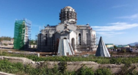
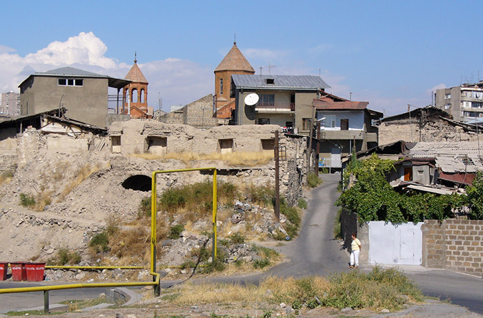
Opposite AUA is Proshyan St. Partway down Proshyan, to the left and elevated above the street, is Kond and Soorp Hovhannes church.
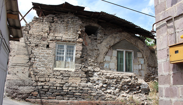
Kond, meaning “hill” in Armenian, is situated on a rocky hill and is bordered by the Hraztan river to the west, Proshyan St. to the east and Saryan and Paronyan Streets. Soorp Hovhannes church is one of Kond’s landmarks. The church was built in 1710 by Melik Aghamal on the site of an older church which was destroyed in an earthquake. Though Persians, Byzantines, and Turks fought and variously occupied this area, by 1502 Safavid Persian rule was established over much of Armenia, including Yerevan. Yerevan’s population consisted mainly of Armenians, Persians and some Turks/Tatars. Of Yerevan’s three main quarters, Kond, Shahar, and Demirbulagh – Kond and Shahar were heavily Armenian populated. Kond was governed by Armenian Meliks or local governors. Much of Kond still retains its old structures and narrow streets, though wealthy Armenians are moving in and replacing many buildings with new structures and unfortunately destroying much of Kond’s interesting character and history.
Alexan Hakobyan, of the Institute of Oriental Studies of Armenia’s National Academy of Sciences, states that Kond was likely fortified on a number of occasions though no fortifications remain. It is speculated that the old church which was destroyed in the earthquake of 1679, on the current site of Soorp Hovhannes, served as the church of the fortress and citadel of Kond. [1] In and around Kond were found buried clay irrigation pipes believed to be either from the Urartian era or the subsequent Armenian kingdom. In the 1940s a silver coin of Alexander the Great (356-323 B.C.), coins of Antioch dating to the 2nd c B.C., and coins of the Seljuk Turk era were found in or near Kond. There also survives the remains of the 1687 Tapibashi Persian mosque in which some Armenians now live. When Persians lost Armenia to Russia, they exited the region. Armenians subsequently inhabited the mosque. Representatives of the Iranian Embassy have on occasion visited this site.
It should be noted that in the early 1800s, the actual city of Yerevan occupied about one square mile, much of it being part of Yerevan Fortress. This fortress was occupied by Turkish and Persian conquerors in frequent succession until Russia finally captured much of Armenia in 1828. Yerevan fortress was destroyed during the Soviet era and replaced by the Yerevan Wine Factory. The outskirts of Yerevan consisted of farms, vineyards and orchards, many of which were owned by wealthy individuals and farmed by sharecroppers. Kond was on the north side of Yerevan, north of Yerevan Fortress. Lynch[2] described Yerevan as existing on two layers: the ground layer upon which business is conducted, and the flat roofs to which the population escapes during hot summer evenings.
Hovhannes Kozern and the Kozern Cemetery
Kond is bordered on the north by an extensive 10th or 11th century cemetery which was used until the mid-1930s. The cemetery boundaries are unclear but it extended more or less along Baghramyan Ave.
In the 9-10th century in the Daron region of Western Armenia lived a learned and highly respected clergyman, Vartabed Hovhannes Darontsi. From the time of his youth, he displayed a great deal of devotion, frequently being seen on his knees praying. Resembling a kneeling camel, he acquired the affectionate nickname “Kozern”, meaning “baby camel”.
Hovhannes Kozern was an astute scholar of the Bible as well as an expert on the Armenian calendar and religious holidays. Elements of his life are available in translations of Chronicle of Matthew of Edessa[3], and Book of History[4], by Arakel of Tabriz. Two episodes are listed below.
In the year 1006, Byzantine Emperor Basil returned from war to great disturbances in his capital, Constantinople. Lamps did not automatically ignite during Easter service in the Church of the Holy Sepulcher in Jerusalem. Seeing this, the Moslems put the Christians to the sword. This occurrence caused heated debate among the Byzantines. What went wrong? The Byzantine emperor requested that the Armenian king and Catholicos send a group of learned vartabeds, including Hovhannes Kozern, to Constantinople to offer their expert opinions. The Armenians did not make the journey. Instead, they replied by letter with a detailed analysis: the Byzantines had miscalculated the date of Easter. After much debate among the Byzantine scholars, and consulting with additional experts, the Emperor concurred with the Armenian analysis. Subsequently many of the Byzantine clergy lost their jobs.
In October 1022-1023 the sky was described as “torn asunder” with a bright light coming from the north accompanied by earthquakes. The sun darkened and stars appeared. The Armenian King ordered the nobility to gather around Hovhannes Kozern to learn the meaning of these terrible, frightening occurrences. Hovhannes was on his knees, weeping inconsolably, stating disaster has been visited upon mankind. According to scripture, the devil had been bound for 1,000 years due to Christ’s baptism and crucifixion, but 1,000 years had now elapsed. The devil is now free and mankind faces an era of hostility to religion, lack of morality, priests will abandon their vows, scholarship will be abandoned. Mathew of Edessa adds that all these prophesies came true with the invasion of the Turks, the sons of Ham.
Later Hovhannnes Kozern moved to Yerevan. When he died the cemetery received his remains as well as honoring him by adopting his nickname “kozern”. Subsequently, when Catholicos Movses and the esteemed teacher Vartabed Melikset died, they were buried alongside Vartabed Kozern.
Little has remained of the Kozern cemetery after it was abandoned in the mid-1930s. The population in the region was in flux. After the conquest of the region by Russia and the Treaty of Turkmanchai (1828), most Persians and other Moslems left Armenia. Many Armenians relocated back to the relative safety of Yerevan, now under Russian control. In the late 19th and early 20th century more Armenians moved from Western Armenia to Yerevan escaping massacres and genocide. Some settled in Kond, and in Kozern erecting makeshift shelters alongside half-ruined monuments. These ultimately were incorporated into, and hidden within, permanent structures.
[1] When, why as a result of what historical changes did the centre of Yerevan have to be moved from Erebuni-Arinberd, Aleksan Hakopyan, 2 August 2019, Institute of Oriental Studies of the RA NAS, available on-line
[2] Armenia – Travels and Studies, two volumes, H. F. B. Lynch, describes travels between 1893 and 1898. Reprints and free downloads are available on-line
[3] Armenia and the Crusades, 10th – 12th centuries, The Chronicle of Matthew of Edessa, translated by Ara Dostourian, 2013, National Association of Armenia Studies and Research, Belmont, MA; an on-line translation by Robert Bedrosian is available at https://archive.org/details/ChronicleMatthewEdessa
[4] Arak’el of Tabriz, Book of History, translated by George Bournoutian, 2010, Mazda Publishers, CA