

NAVITEL announced the release of the navigation map of Armenia, which includes 985 cities, towns and settlements and shows contours and locations of buildings. For Yerevan, the capital of Armenia, the map ensures full coverage of road network and contains a complete database of 25,200 addresses available for address search, ciol.com reports.
The map represents 22,878 km of road graph, and a wide variety of 4,266 POIs will be at hand for search of objects, which might be necessary while moving along the route. The data is represented in Armenian, English and Russian.
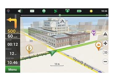
The map additionally includes a 3D-model of the National Gallery of Armenia, which is the central Museum of Fine Arts of the country and one of the largest museums within the Commonwealth of Independent States.
The map of Armenia includes residential and industrial objects and sites of cities, towns and settlements, highly detailed road network, including streets and roads and taking into account traffic directions, interchanges and other important information.